Home / Technology
TECHNOLOGY
4 foundational papers
OPEN TECHNOLOGY
Guided by an open-source mindset, DiO Inc. never hesitates to share ideas and technologies that benefit society. That is why we publish all four foundational papers on our Technology page—complete with creation and revision dates—for free PDF download. Likewise, our patent filings exist solely to prevent exclusive pre-emption by third parties that would block open deployment; our patents are filed because we reject closed business models and wish to protect an open ecosystem.
First edition: November 10, 2026 / Ver. 2.1 finalized: November 12, 2026 / Latest revision (Ver. 2.2, Block Puzzle & machine XYZ carry-in/out integrated edition): November 16, 2026
[Copyright Ownership & Open Technology Publication]
The copyrights to all four foundational papers and the integrated mathematical models published on this page belong personally to the author (Ippitsu). They are openly published with full creation and revision histories for free PDF download as a foundation to support open technological deployment across society.
© 2026 Ippitsu. All foundational papers (Papers 1–4) are personally copyrighted by the author. (Created: Nov 10, 2026 | Ver. 2.1: Nov 12, 2026 | Latest Revision Ver. 2.2: Nov 16, 2026)
※ Academic supervision and recommendation by Prof. Jun Kanda, Professor Emeritus, The University of Tokyo, apply to the 1st Paper only. Figures and checks are reference guidelines and do not judge legal conformity or the pass/fail of inspections.
ICHIGENCHO
Using GSI × PLATEAU × spatial-reasoning AI, we estimate 3D models and floor plans from an address, build up evidence over five steps, and confirm drawings with a matching accuracy of over 95%.
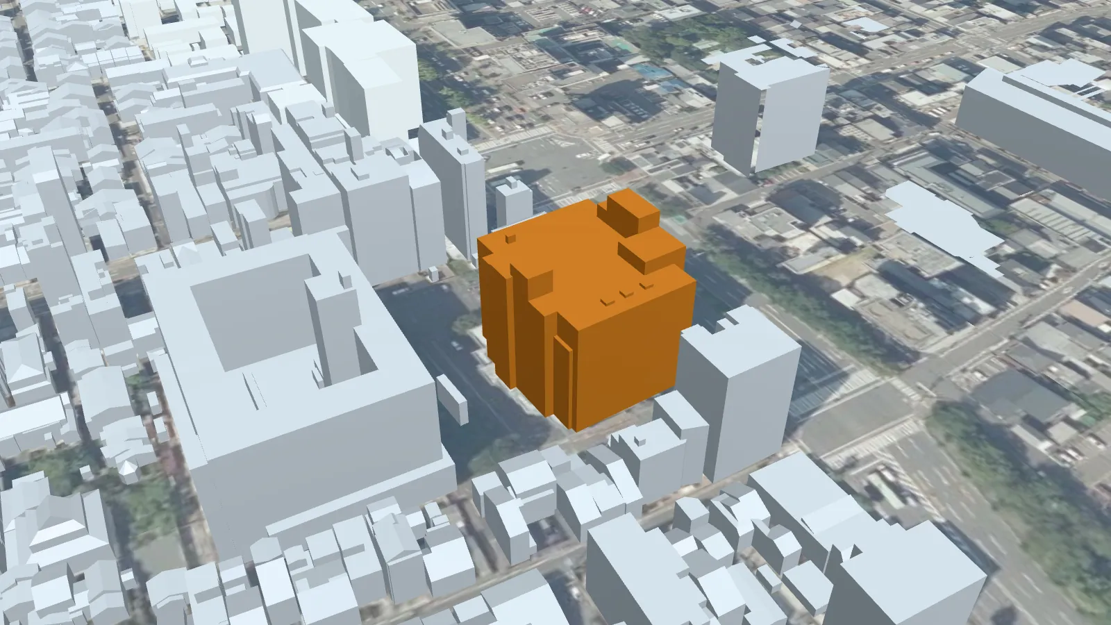
Source: MLIT 3D city models (Project PLATEAU) and GSI tiles (Geospatial Information Authority of Japan), processed by DiO
ACADEMIC FOUNDATION
Drawings for buildings without drawings are raised by back-calculating from public data, on-site photos and walking records, based on the ideas in the following four papers. The resulting drawings are verified by a 6-item automatic check based on building and fire regulations (drawing consistency check).
Yoshimi Ippitsu
First Paper (founding commemorative paper)
First edition: November 10, 2026 / Ver. 2.1 finalized: November 12, 2026 / Latest revision (Ver. 2.2, Block Puzzle & machine XYZ carry-in/out integrated edition): November 16, 2026
Arentable = Atotal − Aslab − core & corridor area
From the outline area, we subtract the setback deduction Aslab as well as stairs, elevators, toilet pipe shafts and shared corridors to find the usable floor area. We also back-calculate the vertical core position so that it satisfies the core-penetration condition — the core runs through the same position from 1F to the top floor.
[First Paper: academic supervision and recommendation] Prof. Jun Kanda, Professor Emeritus, The University of Tokyo
(Academic supervision of the First Paper: spatial structure inference based on the slab area conservation law and Z-axis topological invariance)
Official title of the First Paper: Automatic inference of three-dimensional spatial structure in multi-story buildings using the slab area conservation law and Z-axis topological invariance
In many existing buildings in Japan, drawings from the time of completion have not been kept, and records of daily inspections and repairs remain scattered without being tied to the building structure. To keep using buildings safely for a long time as social assets, it is essential first to correctly grasp a building's structural space and then to build up its maintenance history and preparedness for natural-disaster risks on that basis. The approach adopted by this system — based on the new idea of deriving spatial divisions by "subtracting" vertical structural cores, equipment shafts and regulatory standards from the outer shape in a 3D city model — is consistent with the principles of building engineering and sufficiently practical. I hope that Ichigen-Cho will enable reliable maintenance of existing buildings across Japan and become a foundation for the inspection, repair and preservation of building assets. (Reference translation; the Japanese original prevails.)
Senior advisor, DiO Inc. / Professor Emeritus, The University of Tokyo, PhD — Jun Kanda
* The academic supervision and recommendation apply to the First Paper only (not to the Second to Fourth Papers).
Yoshimi Ippitsu
Second Paper (second report)
First edition: November 10, 2026 / Ver. 2.1 finalized: November 12, 2026 / Latest revision (Ver. 2.2, Block Puzzle & machine XYZ carry-in/out integrated edition): November 16, 2026
Opposed two-viewpoint perspective projection + constraint on corridor length Lc from the outline length → corridor width Wc, ceiling height Hc
Actual dimensions are back-calculated from photos taken facing each other from both ends of a shared corridor with a smartphone on site, and from photos of paper as-built drawings. Keystone distortion in the drawings is corrected automatically from four corresponding points to give a straight-on view.
Yoshimi Ippitsu
Third Paper (third report)
First edition: November 10, 2026 / Ver. 2.1 finalized: November 12, 2026 / Latest revision (Ver. 2.2, Block Puzzle & machine XYZ carry-in/out integrated edition): November 16, 2026
GSI 2D map + building outlines from map data + PLATEAU 3D + on-site GPS walking track
We combine the GSI 2D map, building outlines from map data, the PLATEAU 3D city model and the GPS track walked on site to identify the front road (using only roads within ±60° of the outward direction of the front edge). Results confirmed on site are fed straight back into the reliability of the drawings.
Block Puzzle formula: area-conservation normalization + weighted Voronoi partitioning + move-in/move-out clearance check by 3D Minkowski difference
By combining the footprint and regulatory data from the outside with smartphone walking tracks from the inside that cover only the common areas (never entering private spaces) through the Block Puzzle formula over private-area, common-area and machine/equipment blocks (XYZ dimensions)—area-conservation normalization + weighted Voronoi partitioning + move-in/move-out clearance check by 3D Minkowski difference—we obtain in one pass: ① a floor plan with an area residual of 0.00 m², ② the boundaries between rooms and corridors, ③ equipment pin coordinates, and ④ whether machines can be moved in and out along a route in factories and similar facilities.
In factories and other production facilities, the Block Puzzle also offers "machine / equipment blocks", each holding its X · Y · Z (width · depth · height) dimensions. By mathematically matching the corridor widths, corners, and door, ceiling and beam heights obtained in the 2nd and 3rd papers against the XYZ dimensions of machine blocks, the same data directly supports advance verification of moving machines in and out (whether they pass without hitting corridors, ceilings or beams, and whether they can turn).
Yoshimi Ippitsu
Fourth Paper (fourth report, November 14, 2026)
First edition: November 10, 2026 / Ver. 2.1 finalized: November 12, 2026 / Latest revision (Ver. 2.2, Block Puzzle & machine XYZ carry-in/out integrated edition): November 16, 2026
Single schema bldg-db/1 + two-level Merkle hash (municipal fingerprint Rc × block hash Hc,k) + 2D completion → non-stop upgrade to measured 3D
The 6,772,689 buildings in 1,892 municipalities across all 47 prefectures (95 municipalities / 1,282,287 buildings with PLATEAU 3D; 1,797 municipalities / 5,490,402 buildings with 2D completion) are unified in a single format (bldg-db/1) and split into blocks of up to 2,000 buildings (4,581 blocks, 6,474 files, about 305 MB compressed). Two levels of hashes — by municipality and by block — find and redistribute only changed blocks, so even when a municipality switches to PLATEAU 3D, an update takes only a few files. When a building moves from 2D completion to measured 3D, records such as rooms, inspections and photo pins are carried over unchanged.
Drawings are finally confirmed when all six checks are met. Results are reference guidelines based on regulations and do not replace the judgment of the authorities.
| Equipment | Legal basis / article | Placement guideline | e-Gov law ID |
|---|---|---|---|
| Indoor fire hydrant | Fire Service Act Enforcement Order, Art. 11 | On each floor, a horizontal distance of 25 m or less from every part of the floor to a hose connection (e.g. Class 1 hydrants). Near shared corridors and stairs. | 336CO0000000037 |
| Exit signs | Fire Service Act Enforcement Order, Art. 26 | Exit-door and passage guide lights. At evacuation stairs, the 1F front entrance and corridor corners. | 336CO0000000037 |
| Emergency lighting | Building Standards Act Enforcement Order, Art. 126-4 and 126-5 | Buildings, rooms and evacuation routes requiring emergency lighting, and its structure. | 325CO0000000338 |
| Water receiving tank | Building Standards Act Enforcement Order, Art. 129-2-4 / Waterworks Act, Art. 34-2 | Structure of water supply and drainage piping, management of simplified dedicated waterworks and an annual periodic inspection. 1F outdoors, basement machine rooms, rooftops. | 325CO0000000338332AC0000000177 |
| Power receiving & transforming equipment | Electricity Business Act, Art. 42 (safety regulations), etc. | Safety regulations for electric facilities for business use. Electrical rooms, rooftops, basements, etc. The first equipment to protect during flood warnings (KIKIKURU link). | 339AC0000000170 |
On screen, these are shown with article numbers as "reference guidelines based on regulations". They do not replace the judgment of the authorities.
NATIONAL BUILDING DB
| Data category | Coverage | Units | Buildings |
|---|---|---|---|
| High-definition 3D city model area | Tokyo's 23 wards, Kyoto City, Osaka City: 58 wards | 58 | 859,179 |
| Regional 3D city model area | 37 major municipalities in Kyushu and Okinawa | 37 | 423,108 |
| Wide-area 2D outline & elevation area | 1,797 municipalities and wards nationwide | 1,797 | 5,490,402 |
| Total | All 47 prefectures | 1,892 | 6,772,689 |
Even for newly built or extended buildings, the building's data is updated in real time the moment an address is entered or as-built drawings are loaded on site (Initial Setup Mode) or a walking verification is done with a smartphone (Smartphone Mode).
Instead of recalculating everything every month, we find and update only the blocks where map data shows new construction or demolition, keeping nationwide data current with minimal computing load.
As MLIT PLATEAU publishes new cities or annual updates, we upgrade each municipality in turn from the "wide-area 2D area" to the "3D city model area".
| Tier | Content (example: Nishijin Sangyo Sozo Kaikan) |
|---|---|
| ① Identification ID | PLATEAU's nationally unique building ID (26100-bldg-502331) or an ID based on map building shapes. A facility ID that does not change even if ownership or the management company changes. |
| ② Name & location | Building name, prefecture and reference address (97 Kainokami-cho, Kamigyo-ku, Kyoto, Kyoto Prefecture). |
| ③ Position & elevation | Longitude and latitude of the representative point, and GSI elevation. |
| ④ Floors & measured height | 3 floors above ground, 0 below ground, measured height 20.3 m. |
| ⑤ Use, structure, year completed | Business facility, reinforced concrete, 1921. The protection class (Standard, High, Classified) is selected automatically from the use and used for gate decisions (changeable with one tap). |
| ⑥ Outline shape & front road | Four corners of the outline, frontage W 18.5 m, depth D 42.8 m, building orientation, front road (Nakadachiuri-dori). |
In 3D city model areas, ① to ⑥ are all present. In wide-area 2D outline & elevation areas, the outline, position, elevation and road are present, and floors and structure are filled in through Initial Setup Mode input and outline confirmation.
Owner_ID (owner), Portfolio_ID (group), Building_Master_ID (property), Sub_ID (management company, contractors). Even if the management company changes, drawings and records carry over intact.
Outline area, rooftop portion and total floor area of each floor; rooms (name, area, corners, doors) and equipment positions.
KIKIKURU (inundation, flood, landslide), hourly precipitation, and markers on critical equipment that flash during heavy rain.
Patrol, inspection, emergency and repair history; before/after repair photos with GPS location proof; upcoming inspection dates; on-site walking records and drawing verification results.
RESEARCH
A story set in Kyoto in 1866 that looks again at what the Japanese have left behind.
Deterioration prediction, marker-free floor plan estimation, pre/post-disaster differences, asset valuation and intergenerational connection — organized mathematically.
1 registered and 6 pending. Mechanisms for repair assessment, insurance premium calculation, asset valuation and more are protected as rights.
In systematizing its current spatial mathematical models and the social-asset integration platform Ichigen-Cho, DiO Inc. has accumulated basic research on spatial differential analysis, deterioration prediction and corporate valuation through joint research and academic guidance with the following universities and research institutions.
① Joint research on digitalizing disaster-damage certificates and spatial differential analysis (completed): through joint research with the Disaster Prevention Research Institute, Kyoto University and the Graduate School of Engineering, Kyoto University, we studied determining damage through temporal and spatial differential analysis of pre- and post-disaster 3D building data, and speeding up the issuance of disaster-damage certificates by local governments.
② Research on asset valuation models for facilities and plants combining 3D digital analysis and finance theory (completed): through interdisciplinary joint research with a research team in graduate management and information science — with the participation of Prof. Keiji Murakami (currently Professor [Distinguished Professor], Graduate School of Management, Kyoto University; President, Global Business Society), Prof. Emeritus Kiyoshi Kobayashi of Kyoto University (Specially Appointed Professor, Graduate School of Management) and Program-Specific Prof. Kazuya Aoki, among others — we studied asset valuation models that integrate partial deterioration prediction of structures and plants with corporate valuation in finance (M&A, banking and insurance practice).
③ Academic supervision and recommendation of the First Paper: we have received academic supervision and a recommendation for the First Paper (automatic inference of three-dimensional spatial structure in multi-story buildings using the slab area conservation law and Z-axis topological invariance) (see the First Paper box under "Academic foundation" above). The Second to Fourth Papers are not covered.
The above are past joint research and academic collaborations. The Ichigen-Cho series currently offered (22 categories in total: 12 public and 16 private, including 6 overlapping), the four foundational papers and the seven patents are intellectual property independently developed and systematized by DiO Inc. on the basis of the knowledge gained through this research.
PATENTS
Patents on business and service mechanisms, separate from technical mechanisms (7 in total including related applications). Titles are as stated in the official gazettes (shown in Japanese).
| Number | Application / publication | Title |
|---|---|---|
| P24002 | JP Application 2024-042938 / JP Publication 2025-143617 | Repair assessment system, repair assessment program and repair assessment method for buildings such as high-rise buildings and high-rise condominiums |
| P24003 | JP Application 2024-107812 / JP Publication 2026-007716 | Insurance premium calculation system, insurance premium calculation program and insurance premium calculation method for buildings |
| P25001 | JP Application 2025-010987 (pending) | Plant evaluation system, plant evaluation program and plant evaluation method |
| P25008 | JP Application 2025-196349 (pending) | Asset valuation system, asset valuation program and asset valuation method |
3D Modeling Business and DX Consulting Business: we offer online consultations (video meetings). Pricing for Ichigen-Cho is shown on the SaaS Business page.
Book an online consultationSee Ichigen-Cho
Phone:075-432-8180(9:00–17:00 JST, excluding weekends and Japanese holidays)
No minimum term — cancel anytime. Full refund on your first purchase (until 23:59 on day 30 for monthly, day 14 for annual plans), and your data is kept for 50 days after cancellation.
Hello, I am Shinzo, your AI support guide. Ask me anything about Ichigen-Cho's 5 steps, the 3 screen modes, pricing plans (Method A), foundational papers, or technical terms.
On-site photo support switches to a step-by-step guided mode when the page is opened on a smartphone from a one-time QR issued in Ichigen-Cho on a PC.

